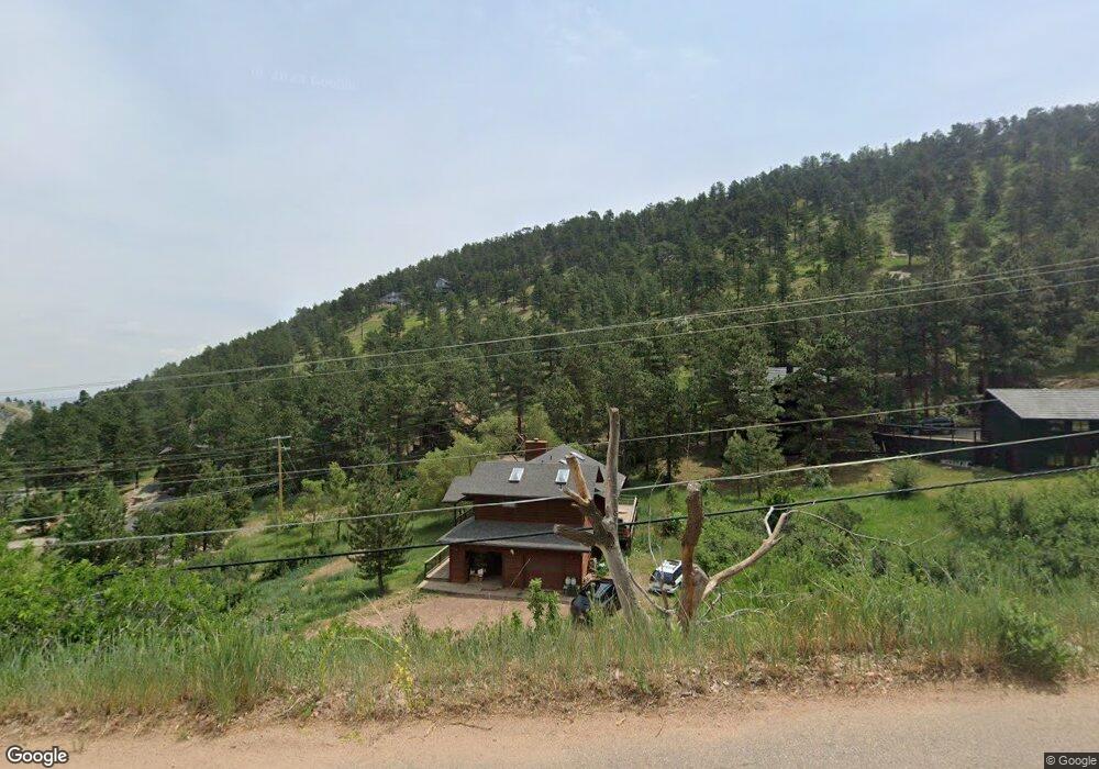
810 N Cedar Brook Rd Boulder, CO 80304
Pine Brook Hill NeighborhoodEstimated Value: $1,197,923 - $1,508,000
3
Beds
3
Baths
1,842
Sq Ft
$753/Sq Ft
Est. Value
About This Home
This home is located at 810 N Cedar Brook Rd, Boulder, CO 80304 and is currently estimated at $1,387,731, approximately $753 per square foot. 810 N Cedar Brook Rd is a home located in Boulder County with nearby schools including Foothill Elementary School, Centennial Middle School, and Boulder High School.
Ownership History
Date
Name
Owned For
Owner Type
Purchase Details
Closed on
Aug 15, 1990
Bought by
Mccray Michael A
Current Estimated Value
Purchase Details
Closed on
Feb 1, 1990
Bought by
Mccray Michael A
Purchase Details
Closed on
Jul 6, 1989
Bought by
Mccray Michael A
Purchase Details
Closed on
Aug 1, 1988
Bought by
Mccray Michael A
Create a Home Valuation Report for This Property
The Home Valuation Report is an in-depth analysis detailing your home's value as well as a comparison with similar homes in the area
Home Values in the Area
Average Home Value in this Area
Purchase History
| Date | Buyer | Sale Price | Title Company |
|---|---|---|---|
| Mccray Michael A | $195,900 | -- | |
| Mccray Michael A | $23,000 | -- | |
| Mccray Michael A | $11,600 | -- | |
| Mccray Michael A | $25,000 | -- |
Source: Public Records
Tax History
| Year | Tax Paid | Tax Assessment Tax Assessment Total Assessment is a certain percentage of the fair market value that is determined by local assessors to be the total taxable value of land and additions on the property. | Land | Improvement |
|---|---|---|---|---|
| 2025 | $7,291 | $75,681 | $17,406 | $58,275 |
| 2024 | $7,291 | $75,681 | $17,406 | $58,275 |
| 2023 | $7,171 | $80,474 | $17,728 | $66,431 |
| 2022 | $6,048 | $62,147 | $14,400 | $47,747 |
| 2021 | $5,756 | $63,936 | $14,815 | $49,121 |
| 2020 | $5,093 | $55,005 | $20,950 | $34,055 |
| 2019 | $5,015 | $55,005 | $20,950 | $34,055 |
| 2018 | $4,834 | $51,941 | $13,680 | $38,261 |
| 2017 | $4,688 | $57,423 | $15,124 | $42,299 |
| 2016 | $4,709 | $50,578 | $17,751 | $32,827 |
| 2015 | $4,475 | $47,346 | $15,522 | $31,824 |
| 2014 | $4,852 | $47,346 | $15,522 | $31,824 |
Source: Public Records
Map
Nearby Homes
- 1280 N Cedar Brook Rd
- 150 Valley View Way
- 166 Valley View Way
- 142 Meadowlook Way
- 795 Pine Brook Rd
- 50 Wildwood Ln
- 2990 Linden Dr
- 1573 Linden Dr
- 2857 Linden Dr
- 1575 Linden Dr
- 228 Lion Point
- 2554 Linden Dr
- 807 Timber Ln
- 335 Lee Hill Dr
- 3945 Promontory Ct
- 4796 6th St
- 4818 6th St
- 700 Utica Ave
- 789 Zamia Ave
- 350 Laramie Blvd
- 770 N Cedar Brook Rd
- 865 N Cedar Brook
- 774 N Cedar Brook Rd
- 966 N Cedar Brook Rd
- 865 N Cedar Brook Rd
- 997 N Cedar Brook Rd
- 771 N Cedar Brook Rd Unit 4
- 982 N Cedar Brook Rd
- 1011 N Cedar Brook Rd Unit 4
- 745 N Cedar Brook Rd
- 901 N Cedar Brook Rd
- 1016 N Cedar Brook Rd
- 1043 N Cedar Brook Rd Unit 4
- 0 Ridge Dr
- 1105 N Cedar Brook Rd
- 635 N Cedar Brook Rd Unit 4
- 772 N Cedar Brook Rd
- 630 N Cedar Brook Rd
- 36 Ridge Dr
- 1204 N Cedar Brook Rd
Your Personal Tour Guide
Ask me questions while you tour the home.