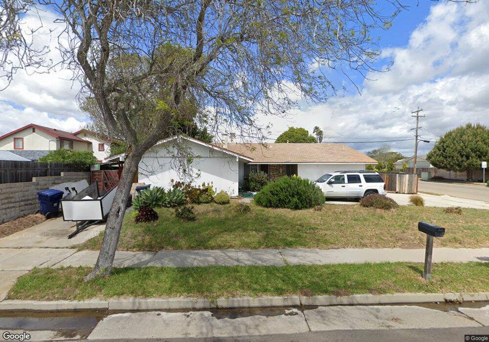
4311 Constellation Rd Unit 1 Lompoc, CA 93436
Estimated Value: $646,323 - $664,000
3
Beds
2
Baths
2,059
Sq Ft
$320/Sq Ft
Est. Value
About This Home
This home is located at 4311 Constellation Rd Unit 1, Lompoc, CA 93436 and is currently estimated at $658,581, approximately $319 per square foot. 4311 Constellation Rd Unit 1 is a home located in Santa Barbara County with nearby schools including Buena Vista Elementary School, Cabrillo High School, and Olive Grove Charter - Lompoc.
Ownership History
Date
Name
Owned For
Owner Type
Purchase Details
Closed on
Jan 22, 2001
Sold by
Whitney Donna K
Bought by
Carrillo Pedro P and Carrillo Arlette
Current Estimated Value
Home Financials for this Owner
Home Financials are based on the most recent Mortgage that was taken out on this home.
Original Mortgage
$176,506
Outstanding Balance
$62,475
Interest Rate
6.98%
Mortgage Type
FHA
Estimated Equity
$596,106
Purchase Details
Closed on
Aug 25, 1999
Sold by
Whitney Ronald E
Bought by
Whitney Donna K
Home Financials for this Owner
Home Financials are based on the most recent Mortgage that was taken out on this home.
Original Mortgage
$38,500
Interest Rate
7.63%
Mortgage Type
Stand Alone Second
Create a Home Valuation Report for This Property
The Home Valuation Report is an in-depth analysis detailing your home's value as well as a comparison with similar homes in the area
Home Values in the Area
Average Home Value in this Area
Purchase History
| Date | Buyer | Sale Price | Title Company |
|---|---|---|---|
| Carrillo Pedro P | $179,000 | First American Title | |
| Whitney Donna K | -- | First American Title Co |
Source: Public Records
Mortgage History
| Date | Status | Borrower | Loan Amount |
|---|---|---|---|
| Open | Carrillo Pedro P | $176,506 | |
| Previous Owner | Whitney Donna K | $38,500 |
Source: Public Records
Tax History
| Year | Tax Paid | Tax Assessment Tax Assessment Total Assessment is a certain percentage of the fair market value that is determined by local assessors to be the total taxable value of land and additions on the property. | Land | Improvement |
|---|---|---|---|---|
| 2025 | $3,276 | $269,700 | $90,399 | $179,301 |
| 2023 | $3,276 | $259,230 | $86,890 | $172,340 |
| 2022 | $3,227 | $254,148 | $85,187 | $168,961 |
| 2021 | $3,261 | $249,166 | $83,517 | $165,649 |
| 2020 | $3,229 | $246,612 | $82,661 | $163,951 |
| 2019 | $3,183 | $241,778 | $81,041 | $160,737 |
| 2018 | $3,140 | $237,038 | $79,452 | $157,586 |
| 2017 | $3,000 | $232,392 | $77,895 | $154,497 |
| 2016 | $2,680 | $227,836 | $76,368 | $151,468 |
| 2014 | $2,623 | $220,019 | $73,748 | $146,271 |
Source: Public Records
Map
Nearby Homes
- 113 Gemini Ave
- 232 Vega Ave
- 106 Galaxy Way Unit 3
- 3939 Mesa Circle Dr
- 3916 Mesa Circle Dr Unit A
- 240 Oak Hill Dr
- 372 Oak Hill Dr
- 0 Oak Hill Dr Unit 24-783
- 250 Saint Andrews Way
- 649 Burning Tree Way
- 3725 Jupiter Ave
- 758 Voyager Rd
- 1445 Calle Marana
- 3660 Rucker Rd
- 972 Pellham Dr
- 832 Onstott Rd
- 892 Onstott Rd
- 1141 Pellham Dr
- 778 Tamarisk Dr
- 2655 Adobe Falls Rd
- 4312 Rigel Ave
- 4401 Falcon Dr
- 4403 Falcon Dr
- 4289 Constellation Rd
- 4405 Falcon Dr
- 4312 Constellation Rd
- 4279 Constellation Rd
- 4280 Rigel Ave
- 4290 Constellation Rd
- 4402 Falcon Dr
- 4321 Rigel Ave
- 4404 Falcon Dr
- 4270 Rigel Ave
- 4344 Sirius Ave
- 4289 Rigel Ave
- 4269 Constellation Rd
- 4280 Constellation Rd
- 4406 Falcon Dr
- 4289 Polaris Ave
Your Personal Tour Guide
Ask me questions while you tour the home.